Friday, 14 September 2012


13th September...........Today we travelled back to the West MacDonnell Ranges to see:

Glen Helen Gorge:......The landscape around Glen Helen is spectacular - a towering sandstone wall is the first thing you see as you arrive. At Glen Helen Gorge the ranges part to make way for the Finke River. The permanent Finke River waterhole is an important refuge in the hot summer months, for all nine species of fish recorded for the Finke, and migrating water birds. From here the Finke River continues and makes its way to the Simpson Desert.


The area's traditional owners believe that this inviting swimming spot is the home of an ancient and powerful Rainbow Serpent, and regard it as off limits.

Ormiston Gorge:......  showed us  the spectacular geology and landforms of the MacDonnell Ranges. The rugged scenery of the Gorge is complemented by a near-permanent water hole.
The water and the shelter of the rocks attract an interesting variety of native fauna and flora, including a number of relict plant species. The recent rediscoveries of the Long-tailed Dunnart and the Central Rock Rat in the Ormiston Gorge vicinity demonstrate what an important role the Park plays as a fauna refuge.


Orchre Pits............The Orchre Pits is a registered site and is protected by Sacred Site and Parks and Wildlife Legislation. The natural orchres in the cliff face provided a source of materials for Indigenous people for their sacred ceremonies the beautiful colours of white, yellow and pink in the rocks makes this a special place. The Arrernte people still use these deposits today.


133.084001541

Ellery 
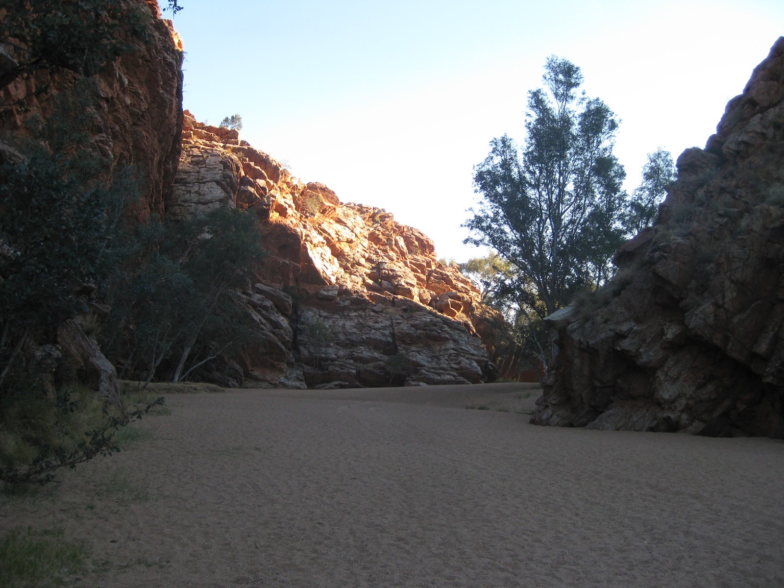
Creek Big Hole:......Ellery Creek Big Hole is one of the most popular and picturesque camping, walking, swimming and picnic spots in the West MacDonnell Ranges National Park. The spectacular waterhole is fed by the West MacDonnell Ranges and surrounded by high red cliffs and sandy Ellery Creek. The permanent water made it a special meeting place for the Arrernte people on the fish and honey ant dreaming trails.


12th September.... Today we headed for the Hermannsburg Heritage Precinct,
Established in 1877 the mission was the initial point of contact between the western Aranda and the European cultures. The mission provided a sanctuary and source of medical assistance for Aranda people. For many years it was the largest settlement in central Australia. Following a spasmodic start the mission was staffed by Pastor Carl Strehlow(from the Lutheran Church)who constructed most of the extant buildings between 1897 and 1910.


Hermannsburg is associated with a number of people of importance to the history of the Northern Territory. Carl Strehlow and his son T.G.H. Strehlow undertook the detailed recording of the Aranda language and culture. The high esteem in which they were held by the Aranda made it possible for them to produce records that still provide baseline documentation for ethnographic research. Hermannsburg was also the home of Albert Namatjira, one of Australia’s most famous landscape artists. Aranda is the 3rd largest language spoken in NT.

10th September....... Today we explored the East MacDonnell National Park and Ranges, places we visited were:

Ross River Resort.....Well that not what I would call a resort, but we are in the middle of Central Australia.

Not much there , but a nice place to stay if that's what you like.

Arltunga Historical Reserve....This was an old mining town, not much left of it. The information centre gave us the history of the area and its people. When gold was discovered in the veins that ran through the East MacDonnell Ranges, people rushed to get their share. With water scarce, it was hard life-style .We were able to see some of the original buildings as well as some of the mining equipment used in those days. The road into here was 4wd gravel. Graeme thought it was good I had other ideas.


Corroboree Rock........The rock itself is an outcrop of dolomite from the Bitter Springs Formation originally laid down in salty lakes 800 million years ago. Dolomite is a soft sedimentary fine grained rock. It is very similar to limestone except magnesium carbonate is the dominant compound rather than calcium carbonate. At the base of the rock you can see dark grey and light grey streaky blobs of 'dalmation rock'. A ring of low ground surrounding the rock makes it look like an obelisk.
 
Corroboree Rock was probably used as an important storage site for ceremonial objects by the Eastern Arrernte Aboriginal people. It is doubtful that it was ever used as a corroboree site, due to the lack of water in the area.

Jessie& Emily Gaps........ Many places in the landscape are associated with the same Dreamtime story. Together these places form a 'Dreaming Trail'. Emily and Jessie Gaps are associated with the caterpillar trail. Emily Gap is the most significant, as this is where the caterpillar beings of Mparntwe (Alice Springs) originated. These caterpillars formed Emily Gap and many of the topographic features around Alice Springs, then radiated out to the edge of the Simpson Desert.
Emily Gap

The first European sighting of Emily and Jessie Gap was in 1871. It was thought that 'Emily' and 'Jessie' were the daughters of Sir Charles Todd, but this was found to be untrue. The basis on which the names are derived is unknown.
Jessie Gap
\


9th September........... We headed out of town towards Standley Chasm 50 kms out of town. The Standley Chasm is located in a private flora and fauna owned by the Iwupataka Land Trust and is operated by Aboriginal family members that are descendants from Aboriginal people that have lived in this area for thousand of years Standley Chasm has been gouged into tough sandstone by flood that, over untold millions of years, have surged down a narrow tributary of the Finke River System. The result is magnificent a deep cleft crowded on either side by craggy slopes that rise 80 meters above the floor.  


Later we travelled to Simpsons Gap located 11 km from Alice Springs, another spectacular rock formation Simpsons Gap is one of the most prominent gaps in the West MacDonnell Ranges. Located 18 kilometres from Alice Springs, it features the towering cliffs of Simpsons Range, a permanent waterhole, and opportunities to spot resident wildlife.


Known as Rungutjirpa to the Arrernte Aboriginal people, Simpsons Gap was the mythological home of a group of giant goanna ancestors. Several dreaming trails and stories cross at this important spiritual site.


Sunday, 9 September 2012


.......... 5th September
Today we headed for Newcastle Waters Rest Area for an overnight stay. We stopped at Larrimah to take photos of " the Pink Panther Hotel"


and headed to the Hi Way Inn for morning tea  just pass Daly Waters turnoff.
We continued on along the Stuart Highway  had lunch at  Elliott and  found when we got to Newcastle Waters Rest area there was no room, we continued on to Renner Springs and spent the night in the van park.


6th September
Leaving Renner Springs we headed for the Devils Marbles for an overnight stay. We stopped off for the information centre which was on Battery Hill, where the museum preserves relics from the Barkly region's pioneering days . We then headed for the Barkly region the home to the incredible Karula Karula (Devils Marbles) large granite boulders. They were scattered across a wide and shallow valley and stood out spectacularly against the rolling hills and level plains of the Barkly Region. It was just a wonderful place. We climbed the boulders and witnessed a spectacular sunset. We could hear the dingoes howling, but couldn't see any.


7th September
Leaving the Devils Marbles we headed for Alice Springs and whon did we meet on the road??


making a couple of stops at Barrow Creek where there was an old Telegraph Building.


and at Ti Tree for diesel. We stopped at the Tropic of Capricorn Marker.

Tuesday, 4 September 2012


3rd September

Today we left Boab Caravan Park at Katherine to go to Mataranka Homestead and the Thermal Springs. It wasn't a long trip only 107 klm's settled in had lunch and down to the springs for a swim, just beautiful .We noticed when we were in the pools a young aboriginal family who came to the pools to bath their 3 young children and mum had a dip. We were told that they had caught a tortoise, had started a fire, (which we noticed) cooked the tortoise and had eaten it. There are Wallabies and Peacocks walking around the caravan park


4th September........... We decided to stay another day at Mataranka to enjoy the thermal springs and do some sightseeing. On  the way into town we had  a look at  the replica of the original homestead from the movie that was filmed here "We of the Never Never" When we were in the post office we asked the lady where the historical cemetery was. She gave us a book "The Girl Who Talked to the Stars' written about Bett Bett, the Little Black Princess of the Never Never, and told us to drive 12kms out of town where we were able to see many old graves of the people of whom the book was written about. Back to the van for lunch and a swim.


Monday, 3 September 2012


25th August...........Today we toured the Warradjan Aboriginal Cultural Centre which gave us an understanding of the connection Kakadu's Aboriginal owners have with this special part of the Top End. We learned about the stories that gave them their laws. The displays were very interesting, but we had a lot to read. Sorry no photo's as we were not allowed to take them.

We were picked up at our caravan park for our Yellow Water Billabong Cruise. Yellow Water is home to crocodiles, birds, barramundi and many other wildlife. This is all part of the Alligator River system and it flows for over 200 kilometres.


Paperbark trees, pandanus and freshwater mangroves line the bank, and the water is dotted with beautiful pink and white waterlilies.


We also saw a croc take a  barramundi. 
 

26th August.......We visited the Bowali Visitor Centre in Jabiru where we watched a 25 minute audio visual of Kakadu's landscape and gave us a better understanding of the wet season and what happens to the landscape, animals and bird life.

 
We went onto Nourlangie Rock Art Site which has served as a shelter for the aboriginal art for thousands of years. We saw paintings such as Namarrgon, the Lightning Man and gave us a better understanding the relationship of the people to their country and beliefs. The track wasn't too bad but well worth the climb in the end.


27th August........ We started off at around 10.00am for Jabiru for shopping then off to Cahill's Crossing where the East Alligator River forms the north eastern boundary between Kakadu National Park and Arnhem Land.


We got talking to people one of whom lives in Wollongong and they offered Graeme an opportunity to fish, the only trouble the catch had to be more than 55cm his wasn't, but by saying that the largest we saw caught was 80cm by one of the girls (I had my photo taken holding the fish).


We went for a Guluyambi boat cruise along the East Alligator. Our guide on this cruise was Neville an aboriginal from Arnhem Land, he was very informative, we gained more insight into the traditional culture, local mythology, the river's abundant food chain as well traditional bush survival skills, this was done when we got off the boat in Arnhem land and Neville displayed his skills with the spears.
 

 Ubirr (oo beer). This is where we saw the famous rock art. We were able to listen to a guide who was explaining the paints and Graeme took many photos. Later we climbed a moderately steep 250 metre rock to watch sunset across the floodplains and to the back the rock escarpment, it was probably the highlight of our visit to Kakadu.


 28th August ..... Left Cooinda for Leliyn Edith Falls Camping Ground for a two nights stay. A picturesque waterfall this section of the Jawoyn-owned is part Nitmiluk National Park.

 
29th August.........  Woke up around 8.00am, had breakfast did washing than headed for a swim, just beautiful water temperature Graeme was able to stay in for about 1 hour while we talked to people from the Caribbean. They had a very interesting life style. Went back for lunch had a sleep and off for another swim. All day today we were entertained by the Bower Birds gathering different things for their nest and their mating habits. Graeme was also able to take photos of the bird life here. Sunset was beautiful, but the main thing we are enjoying the peace and quiet of the area. Tomorrow we head back to Katherine.


30th August
We left around 9.09am and headed for Katherine along the Stuart Highway. 33 Kms out of Katherine we were flagged down by a motorist who informed us that our passenger side tyre on the van was smoking and was starting to catch fire. They drove off  and we were left to solve to problem. Graeme waited for a while until the wheel was cooler to jack up the van.

I knew by the look of his face that we had a major problem. The brake drums were burnt out and maybe other damage.


We had no service on our phone, so we waved a passing motorist. Thank heavens help came as Peter & Jan stoped,  they had phone connection. We were able to ring the tow truck and Jan organised accommodation in  a cabin at the Boab Caravan Park where they were heading at Katherine

31st August      Graeme went and played golf with Jan & Peter and I had a lazy morning sitting on a deck chair and read my novel. Had a phone call from Graeme to say that they were on the last hole and to come and join them for a drink. Home for lunch to Jan & Peters van, just nibbles and lots of talk. Later that afternoon we had a swim and Graeme went and got the van. After settling in Graeme and Peter cooked a bake pork meal, us the pork and Peter the vegies. It was a good night.

 
1st September   Went to the markets with Peter & Jan for breakfast, back to the van for a quiet  afternoon, swim and off the Katherine Railway to see the departure of The Ghan which was heading for Adelaide.